Hands-on Geography

Hands-on Geography

I will admit, as I planned and plotted for this year, I wondered if maybe—just maybe—I’d tried to do too much. After all, the activities of 3 different geography curriculums did seem a little excessive. But I couldn’t help but love how the three complimented each other so well, one filling in for the gaps of the other two and vice versa.

Surprisingly, we’ve had plenty of time for everything! I’m stunned and amazed at how smoothly all of the components have fit together. Just to clue you in, Oldest does the maps from Tapestry of Grace on our magnet board; this is probably his most intensive mapwork. Then, Oldest and Middlest complete the simpler map work from Story of the World before listening to their audio history lesson, and we play Mr. Sprinkle with that map. Quite honestly, this map time is more for Middlest, but Oldest enjoys the fun activity and review.

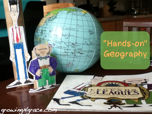
Last but not least, I added Leagues and Legends to our geography mix. Here’s why: my son needed to know how to use a map, not just how to locate Scandinavia and Normandy. L&L, as we affectionately call it, covers the equator, longitude and latitude, directions on a compass, how to draw your own map, and much more. The storybook tells a funny, memorable dialogue among three men, Mr. Tardy, Mr. Longitude, and Mr. Latitude. It’s short and thorough, and very entertaining.

Then, there’s the activity book, which has been a highlight for Oldest. There are enough activities to work one a week for about half the year. Some of the activities include toilet paper roll puppets for the characters, drawing a map of your room or neighborhood, coloring the different points on a compass, making your own compass, etc. And best of all, most of the activities are things he can complete by himself with a little instruction.

Rather than one more thing to do, Leagues and Legends has been another hands-on component to geography that my son looks forward to every week.

Fun with Maps

We’ve done a lot of experimenting this year as we’ve launched our first year of classical curriculum. I knew that would be the case, which has helped me to keep an open mind when things haven’t gone as well as I had hoped. Map work is one of those areas where we’ve done a lot of experimenting, trying to find the best method for learning our maps.

I love map work. It is a definite kinesthetic activity to add to a history study, and there are lots of different ways to explore them. I know, because I’ve tried several.

First, I made labels for the kids to stick to the maps as we learned the different areas. That worked okay, but I wasn’t thrilled. It was hard to review everyday, and they only got to put the stickers on once a week (not to mention it took a lot of label making).

Then, I put the map for the week in a page protector and had Oldest trace it each day with a dry-erase marker. He enjoyed that, but I wasn’t convinced that he was really learning all that I wanted him to learn. And it did demand a little bit of fine motor skills.

So we’re on our third attempt. And right now, I’m thrilled with it. I keep the answer key map in a page protector in his assignment notebook for him to review (we also review together during our read-aloud time). Then, I have a blank version of the map magnetized to the side of our file cabinet. I made “labels” (strips of an index card with a piece of adhesive magnet tape on the back) for him to stick to the map as he reviews.

Tapestry of Grace

Each day, I have assigned three or four new magnet labels for him to find on his map and label on the blank map. He adds his new magnets and reviews the old magnets each day. The activity is pretty independent, as he has the answers in his notebook. He has to find the sea or the city or the island name, etc., on his own. Of course, he loves to show me his work, and I review with him once he’s found the places.

It’s an activity that he is enjoying doing over and over again. After all, what kid doesn’t like to play with magnets. He’s really learning these locations from all the review. And though it takes a little more time for me to prep at the beginning of each week, it doesn’t take as much one-on-one during the week.

I also am going to be more selective with my maps and try to select maps that build a broader view each week, rather than skipping around the region. That way, I can reuse and review the magnets that I have made, and Oldest will get a better view of where his maps fit in with the big picture.

So far, it’s been a big win all around.


TimeMaps by Knowledge Quest Review

Knowledge Quest
TimeMaps, produced by Knowledge Quest, is both timeline and map in one product.

There are several components to this product. First, TimeMaps are grouped by topic.Photobucket

Ancient China

The Rise of the Roman Empire

The Fall of the Roman Empire

The Rise of Islam

European Exploration and Discovery

The Black Death

The Atlantic Slave Trade

In flash format, a series of maps highlights the different changes within a topic. Watch the Roman Empire swell in its might (and see the rise and fall of the Persian and Greek empires in the process.) Interactive links and icons provide more information on what is happening on the map. Questions are also provided to guide your discussion with your student.
Photobucket

Photobucket
Another element is the map timeline, accessed through the “TimeMaps of World History” link.

TimeMaps

timeline maps

By clicking on different dates on a timeline, changes around the world are indicated on the map. Again, this map includes links that provide more information when you hover over them. “What’s happening in the world” provides a brief summary to read to the student.

TimeMaps timeline and maps

Lesson plans and activities are also provided, but I found that these were aimed largely at older children, probably dialectic level. Assignments included creating a timeline or researching a topic and writing an essay.

TimeMaps by Knowledge Quest

My kids loved to see the places that we’ve been studying in our geography. And they loved to “uncover” the facts on the maps through the interactive links. Though we’ve already enjoyed this product, I can’t wait to put it into context with our Tapestry of Grace studies. From ancient history to the Enlightenment, these maps and eventually the activities will be something we’ll use for years! I was also thrilled to find maps and information on the Maya and ancient Mexico as well as Mesopotamia within these products, especially since these places and time periods are often difficult to find information and activities for.

My husband was also impressed. He’ll be taking a class on Islam in the fall for his ThM in apologetics, and the Rise of Islam has a lot of information to provide him with a background for that class.

I love this product; it is just as cool as it looked like it would be and is definitely worth the price. Topics can be purchased individually for $9.95 or as a set for $44.95. Visit the site for more information and to watch a brief video touring the product.

You can also read more reviews about TimeMaps or Knowledge Quests MapTrek series at the Schoolhouse Review Crew.

Photobucket


Disclaimer:  As a member of the TOS Crew, I received this product, at no cost to me, in exchange for my honest review.  All opinions are mine.